Are Floods Dramatically Increasing Due to Climate Change?
Part one of a two-part series: The natural hazard of floods.
-
-
Share
-
Share via Twitter -
Share via Facebook -
Share via Email
-
Originally published by The Liberal Patriot as part of a content partnership with Patrick Brown and the Breakthrough Institute. Subscribe to their Substack here.
Flooding is among the most consequential natural hazards and globally accounts for tens of thousands of deaths per year and hundreds of billions of dollars of damage per year.
When rivers overrun their banks or flash floods occur from extreme rainfall, many media outlets will reflexively report on the flooding as though we are in a fundamentally new situation due to climate change.
Consider the following headlines:
- The Washington Post when major flooding hit the United States last summer: “Floods, fires and deadly heat are the alarm bells of a planet on the brink.”
- The New York Times headline reported major floods in Vermont last year, “Showed the Limits of America’s Efforts to Adapt to Climate Change.”
The Times article began: “This week’s flooding in Vermont, in which heavy rainfall caused destruction even miles from any river, is evidence of an especially dangerous climate threat: Catastrophic flooding can increasingly happen anywhere, with almost no warning.”
A few paragraphs later, we hear: “‘It’s getting harder and harder to adapt to these changing conditions,’ said Rachel Cleetus, policy director for the climate and energy program at the Union of Concerned Scientists. ‘It’s just everywhere, all the time.’”
But is it actually everywhere, all the time, and are we progressing into a fundamentally new world of flooding due to climate change?
When considering the risk of natural disasters like floods, the UN’s Intergovernmental Panel on Climate Change (IPCC) has adopted a useful framework for breaking down the risk of impacts.

Under this framework, the risk of impacts from a natural disaster can be thought of as resulting from the combination of natural hazards, exposure, and vulnerability.
- The natural hazard is the physical event like the flood that has the potential to cause loss of life, economic disruption, or environmental degradation.
- Exposure refers to the presence of people, resources, or infrastructure in harm’s way of the natural hazard.
- Finally, vulnerability is the propensity of people, resources, or infrastructure to be adversely affected when exposed to a hazard.
Essentially, a natural disaster can only occur if things we care about are exposed to a natural hazard and they are vulnerable to it.
This framework is useful for considering the underlying causes of flood disasters because it is clear that, on the many-decade timescale that climate change progresses, there will also be major changes in exposure (e.g., the number of people and what proportion live in floodplains) and vulnerability (e.g., weather prediction, behavior, flood control, storm sewer systems, and other infrastructure).
If we focus exclusively on climate change's influence on the natural hazard, we will miss a major part of the story.
In these two posts, I’ll examine all three components of floods. In Part One, I’ll take a look at changes in the physical flood hazard, and in Part Two, I’ll examine changes in human exposure and vulnerability to floods.
The Flood Hazard
The flood hazard is simply the inundation of normally dry land. Floods are often classified into coastal flooding and inland flooding, both river flooding and rainfall flooding (river flooding is often caused by rainfall but can also be caused by, e.g., rapid snowmelt).
Sea-level rise is an unequivocal result of global warming, and the five inches of global mean sea-level rise we have observed over the past 50 years unquestionably exacerbates global coastal flooding.
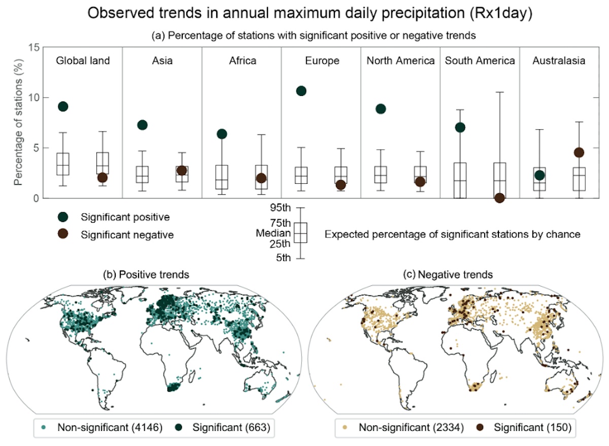
When it comes to inland flooding, however, the story is more complicated. The fundamental theory for why warming should increase inland flooding comes from the so-called Clausius Clapeyron relationship, which tells us that warmer air can “hold” more water—about seven percent more water vapor per °C. That means that, all else being equal, a warmer climate is one where there is more water vapor in the atmosphere and thus more water available to condense and rain out of the atmosphere when rain occurs. Studies have shown that, on average, globally, we do indeed see increases in extreme precipitation roughly in line with this seven percent per °C.
All else is not necessarily equal, though, and the degree to which warming affects other parts of rainstorm dynamics can also play a role. There’s also simply a lot of random natural variability in when and where extreme rainfall happens to strike, which obscures the underlying effect of warming.
These factors (and others) mean that the increase in extreme precipitation is not universal, and plenty of locations have seen decreases in extreme precipitation despite warming.

To better understand the influence of warming on extreme precipitation (and therefore how we expect it to change in the future) at the location-by-location level, we run climate models. There are dozens of climate models that differ slightly in their construction and the answers that they give us. The range of output from models serves as a proxy for our uncertainty on the effect of warming on extreme precipitation.
The IPCC shows climate model simulated changes in extreme precipitation and the range across models. The maps below not only show the median model change for 2°C of global warming in the middle panel but also the 5th percentile of the models in the left panel and the 95th percentile of the models in the right panel.

We see in the middle map that over almost all land locations, the median climate model indicates an increase in the magnitude of extreme precipitation. However, if we had very high confidence in warming’s influence on changes in extreme precipitation at any given location then that would be reflected in the models' universally agreeing on the sign of the change. However, we see that in the 5th percentile map, there is a lot of brown, indicating that some models, at least, actually project a decrease in extreme precipitation over a lot of land locations as it gets warmer.
Let’s bracket that uncertainty for the moment and assume that the median model is correct and that we can expect warming to cause extreme precipitation to increase over almost all land locations. Does this translate directly into an increase in the flood hazard? No.
There are many other factors to consider when thinking about the link between extreme precipitation and flooding but two stand out as being particularly consequential.

One is the effect of the warmer atmosphere on the amount of moisture in the soil before an extreme rainfall event occurs. The same mechanisms that allow more rain to fall out of a warmer atmosphere will also cause more water to evaporate from the land surface prior to the rainfall event. This means that as the atmosphere warms, soil will often have more capacity to absorb the additional rainfall when it does occur.
The other major factor is that many river floods are not driven by extreme rainfall but rather by the rapid melting of snow that has accumulated over the winter in higher latitudes and elevations. As it warms, more precipitation falls as rain rather than snow, which reduces the average snowpack in most locations such that spring melting results in a smaller release of water.
Those two countervailing influences on floods are potentially large enough to offset the effect of more extreme rainfall. With that in mind, let’s look at the overall data on floods.
Floods are difficult to quantify and measure globally, especially before sufficient satellite coverage came online in the early 2000s. Most studies on floods therefore look at changes in extreme streamflow—the rate of water movement in rivers. We have high-quality, long-term data on streamflow in many locations, but it is still lacking in spatial extent.

Nevertheless, we see substantial diversity in the sign of trends where we have good data, and overall most observational studies show no increase in floods globally and, if anything, show decreases. The IPCC essentially says that it is a wash and concludes:
There is low confidence about peak flow trends over past decades on the global scale, but there are regions experiencing increases, including parts of Asia, Southern South America, north-east USA, north-western Europe, and the Amazon, and regions experiencing decreases, including parts of the Mediterranean, Australia, Africa, and south-western USA.
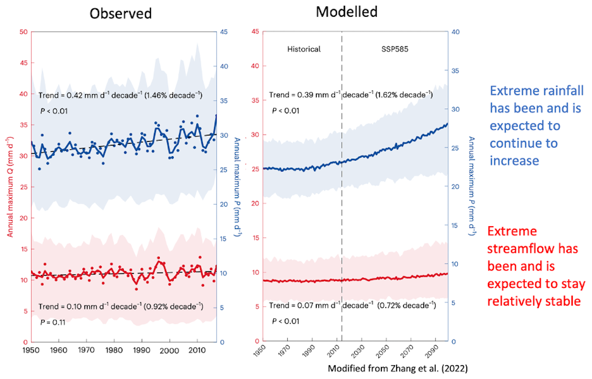
Research has also shown that trends depend greatly on the type of flood. As mentioned above, we have observed (and climate models project) that floods due exclusively to extreme rainfall should increase in magnitude while floods due to snow melting should decrease in magnitude.
This means that both observations and models indicate that globally, extreme rainfall is and will continue to increase, but flooding (as quantified from extreme streamflow) should stay relatively stable.

With no clear coherent change in floods globally, the IPCC cannot “attribute” any change to human-caused increases in greenhouse gas concentrations and thus concludes that:
In summary there is low confidence in the human influence on the changes in high river flows on the global scale. In general, there is low confidence in attributing changes in the probability or magnitude of flood events to human influence because of a limited number of studies, differences in the results of these studies and large modeling uncertainties.
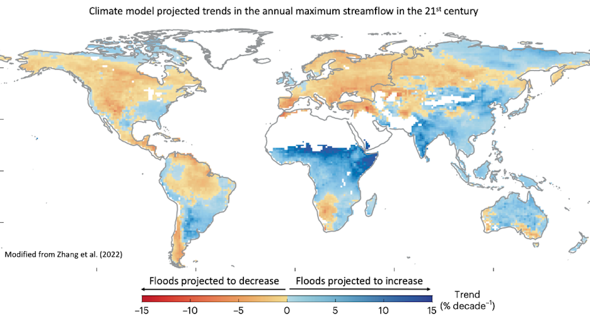
However, the lack of coherent global change does not mean that we don’t expect change at the local level. We just expect decreases in some locations and increases in others.

Concerning projections, the IPCC concludes that:
In summary, global hydrological models project a larger fraction of land areas to be affected by an increase in river floods than by a decrease in river floods (medium confidence).
Though the map above indicates to me that it is pretty close.
I began this part by pointing out that changes in flood disasters will depend on not just the flood hazard but also changes in exposure and vulnerability. Here, we have seen that climate change should enhance extreme rainfall—an important influence on the flood hazard, but far from the only one. More extreme rainfall should, in turn, increase the flood hazard in some locations, but it may not be enough to increase the flood hazard globally. That means that changes in exposure and vulnerability have the potential to be the dominant drivers of changes in flood disaster risk both in the past and going forward. I’ll delve into those two aspects in the next part.

