Will a Cold European Winter Exacerbate The Energy Crisis? Pt. 2
What the modeling predicts, as of September 30th.

-
-
Share
-
Share via Twitter -
Share via Facebook -
Share via Email
-
See here for background on the European energy crisis and its relationship with winter temperatures.
What is the European weather outlook for the winter of 2022/2023?
- Variability in European winter weather is substantially impacted by a weather phenomenon called the North Atlantic Oscillation, which affects whether northern Europe is downstream of mild, moist air from the north Atlantic or cold, dry air from the Arctic.
- The North Atlantic Oscillation has been demonstrated to have some predictability on seasonal timescales, but models do not yet paint a consistent picture regarding the state of the North Atlantic Oscillation for this upcoming winter.
- Models are consistent, however, in predicting a roughly 60% chance that this winter will see average to above average temperatures over Europe. The best estimate would be 0°C to 2°C above recent average winter temperatures.
- A colder than average winter, though, is still very much a possibility (about a 40% chance).
It is also more likely than not that the United States and East Asia will experience warmer than average winters. There is roughly a 70% chance of a warmer than average winter in both the continental United States and eastern China. - If Europe, the United States, and China all do have warmer than average winters, it would ease pressure on global demand for natural gas for heating and electricity.
How do dynamical forecasting models work, and what do they say?
Dynamical forecasting models start with our best estimate of the state of the ocean-atmosphere-land system and then use physical equations to project into the future how all of those systems will co-evolve. A single simulation of a model will produce weather predictions into the future for as long as the model is run (many months in this case). Any given run of the model represents a single possible trajectory of the weather.
Because of the butterfly effect, the day-to-day sequence of weather events produced by such a simulation cannot be taken seriously beyond the time horizon of a couple of weeks. But, certain weather conditions can be more likely than others because slowly evolving parts of the climate system can favor them. In order to investigate if there are any tendencies for certain types of weather patterns to be favored, a dynamical forecasting model can be re-run with slightly different initial conditions (akin to the butterfly flapping its wings). If we see consistent patterns emerge across many of the model runs (like warmer than average temperatures in a given location), that means the model is telling us that some slowly evolving part of the climate system (sea surface temperatures or sea ice extent for example) is probably favoring that particular pattern.
What does the European Dynamical Model predict right now?
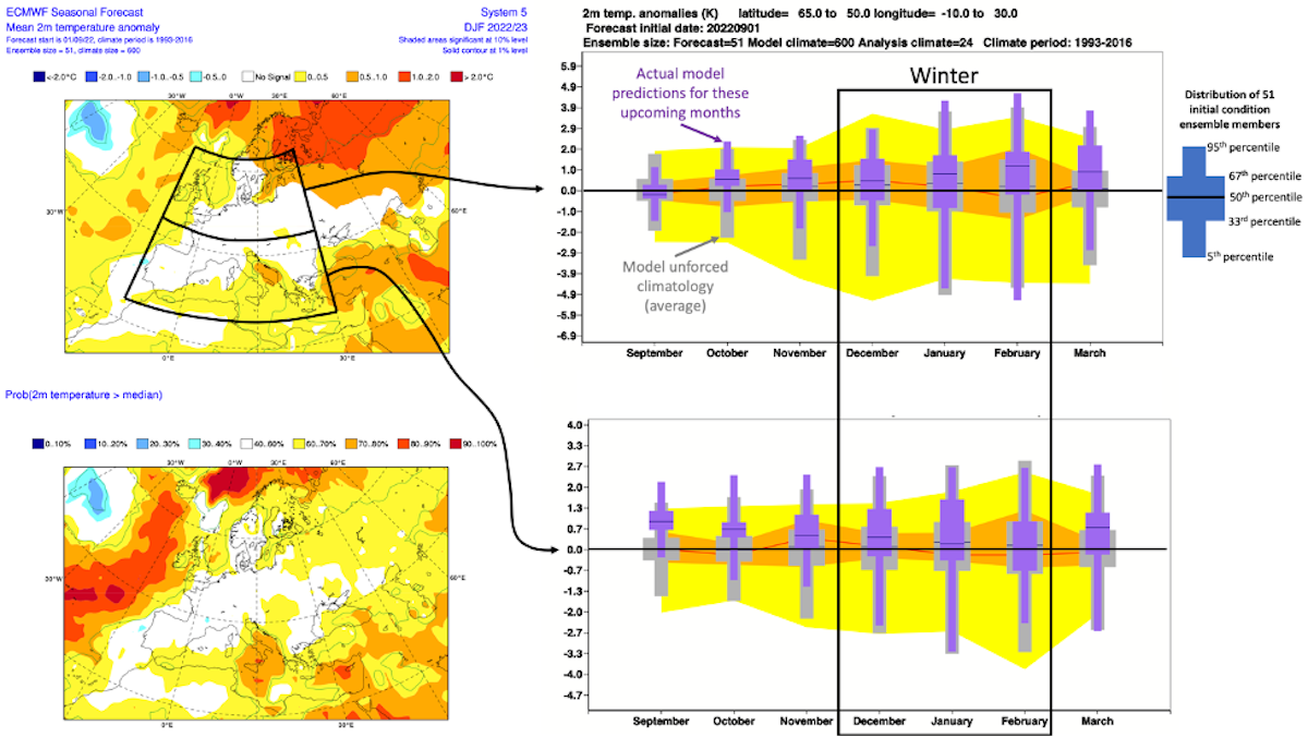
The historically best performing seasonal forecasting system coming out of European weather and climate centers is the European Centre for Medium-Range Weather Forecasts’ SEAS5 system.
As of this writing, the SEAS5 indicates that there is about a 60% chance that the North Atlantic Oscillation will be, on average, in its negative phase this winter. These probabilities are calculated by looking at the individual model runs (51 in this case) and counting how often the North Atlantic Oscillation is positive compared to negative.
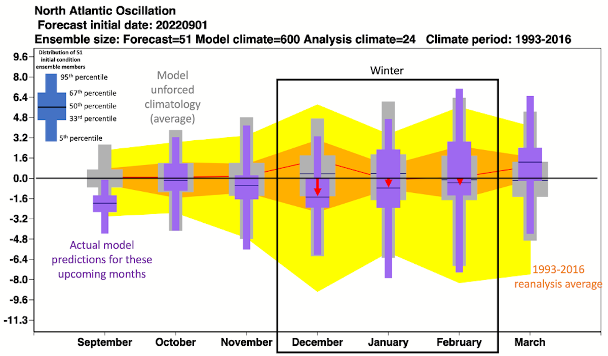
Typically, a negative North Atlantic Oscillation would correspond to colder than average conditions in northern Europe and as well as reduced wind—both of which would exacerbate the energy crisis as people need more fuel to warm their houses and there is less wind energy available.
However, other factors, like less than average sea ice in the arctic and warmer-than-average ocean temperatures in the northeast Atlantic, may sufficiently overwhelm the negative North Atlantic Oscillation flow pattern to cause a roughly average to warmer-than-average European winter (Figure 2). The SEAS5’s 51 runs, for example, predict a European winter roughly 0.5°C above the 1993-2016 average.
What does the United States Dynamical Model predict right now?
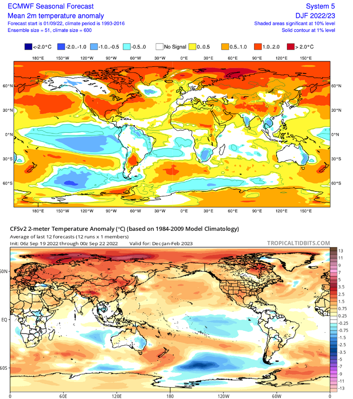
The historically most prominent seasonal forecasting system coming out of US weather and climate centers is the National Center for Environmental Information’s Climate Forecast System (CFSv2).
In contrast to SEAS5, this model indicates a pressure pattern indicative of a positive North Atlantic Oscillation, which would steer more heat, moisture, and wind than usual into Northern Europe—all good from an energy supply and demand perspective. CFSv2 is thus more confident than SEAS5 that the upcoming winter will be warmer than average (CFSv2 also starts from a colder “average” than SEAS5 because its baseline is 1984-2009 rather than 1993-2016). CFSv2 predicts a European winter roughly 1.75°C above the 1984-2009 average with a weak indication of above-average precipitation (Figure 3D).

Because natural gas markets are increasingly affected by global supply and demand, heating demand in other major economies this winter will also impact European prices. Looking globally, SEAS5 and CFSv2 also predict warmer than average weather in most of the United States and China (Figure 4). This is more good news from an energy demand perspective.
Do other seasonal forecasting systems offer different conclusions?
In short, no. In addition to the CFSv2 and SEAS5, there are many other seasonal forecasting models. Some additional models combine to form what’s known as the North American Multi-Model Ensemble. Statistical post-processing techniques can be applied to these models to remove known biases and weight predictions toward models that have a better track record in certain circumstances. One organization that does this is The International Research Institute for Climate and Society (IRI) at Columbia University. IRI’s meta-model also predicts roughly average to above average temperatures over Europe, China, and most of the United States this upcoming winter (Figure 5).

Overall, models do not yet paint a consistent picture regarding the state of the North Atlantic Oscillation for this upcoming winter, but models are consistent in predicting that it is more likely than not that this winter will see roughly average to above average temperatures over Europe. The best estimate would be 0°C to 2°C above recent average winter temperatures. This would be a welcomed development as it would ease the European energy crisis relative to what we’d expect in a harsh winter.
We will update this outlook roughly biweekly as the winter draws nearer and fresh runs of the models become available.


